

100 Miles of SingleTrack
The course
Gariwerd/Grampians national Park
MOUNt Zero to Dunkled
Distance: 162km
Elevation Gain: 7700m+-
Course: the entire Grampians Peaks Trail
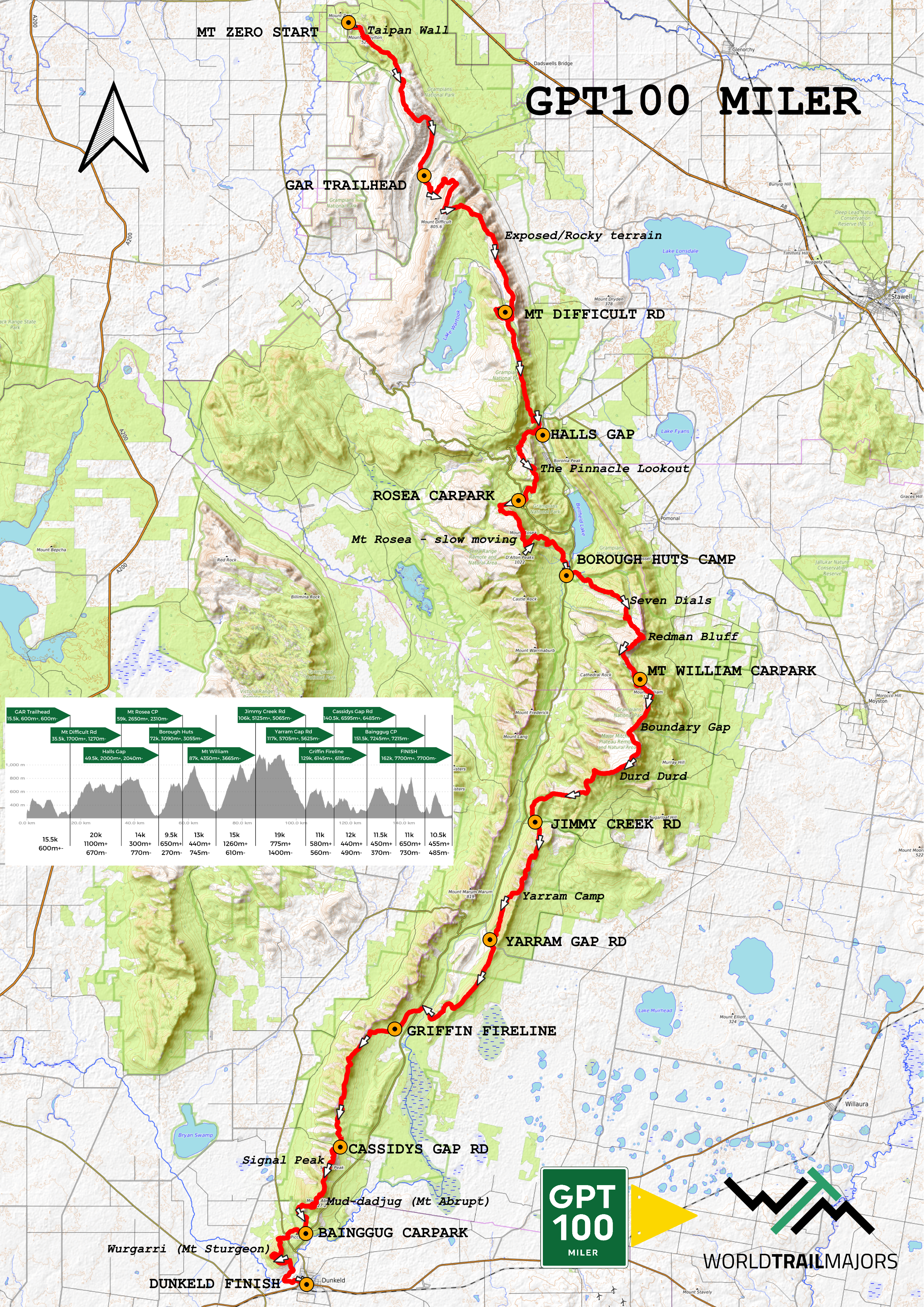
The race is run on the Grampians Peaks Trail, a point to point 100 mile trail (162km with 7700m of ascent), which traverses the rugged mountain range of the world-renowned Grampians National Park. The trail is purpose built to encompass all the beauty that the Grampians, in Gariwerd country, has to offer.
The trail starts in the north at Mt Zero Picnic Area and heads south all the way to Dunkeld. Along the way runners will pass 12 campsites each with stunning huts built in the most secluded areas along the route. There will be 11 aid stations to assist the runners at road crossings, trails heads, Halls Gap and public campgrounds.
Much of the journey goes through remote wilderness areas, where the rocky trail is a welcomed source of safety. There is a real sense of connection to nature and place. The race will be broken up into four sections each with major aid stations at each completion.
Course PREVIEW
Watch the below video, produced by Victoria Dorph, and immerse yourself into the Grampians Peaks Trail. Experience the trails with our Course Director, Joseph Dorph and trail beasts Majell Backhausen and Steven Monohan as they spend three glorious days running the GPT100 Miler.
Description of the Grampians Peaks Trail
The Course starts with the iconic climb up the rock slab “Flat Rock” from Mount Zero Picnic Area to reveal the entirety of the world famous Taipan Wall. After running under the rock wall the trail finds its groove as it toggles between a thin, rocky, uneven surface and a smooth dirt ribbon. There are many shorter climbs and descents along the section through to GAR Trailhead, where the first aid station awaits. Fuel up well and take extra water and nutrition because the next section is a real doozy.
There are numerous waterfalls for the next few miles before beginning the long and ever changing climb to GAR/Mt Difficult itself. Most of this long and exposed section has continual 360 views of the entire Grampians grandeur, which is a common theme throughout the whole run. Runners don’t actually summit GAR but rather turn to descend a very technical and choppy trail.
Once climbing again the trail goes between smooth and runnable to very rocky and uneven as it climbs ever so slowly and endlessly to Mt Difficult Rd aid station. This section will challenge every runner’s will. Take extra care of yourself through here.
The section from here to Halls Gap is relatively faster than the previous. However it does start with a slower climb, grinding up to Wartook Lookout. Once here, stop, soak in the view of the four lakes and surrounding Peaks. The course then follows a mostly smooth trail on a long descent to Halls Gap. Once turning left at Chatauqua Peak the 50k runners can see the finish. Runners take an enjoyable trail through the arboretum and caravan park to the town centre of Halls Gap. The 50k runners can celebrate; the Stage Race runners can be proud to have gotten through day 1; and the Miler runner’s journey has only just begun!
The course follows the Wonderland Trail through to the Grand Canyon Trail and up to the famous Pinnacles Lookout. From here, it continues along a technical rocky trail, with some ducking and weaving to Rosea car park aid station. This quick pitstop will be critical before tackling the climb up to Mount Rosea, and then traversing along the top, past some cliff edges and a scrambling descent. Just before you'll begin to tire of the technicality, the trail opens up to an 8km flowy descent, which is soft underfoot and all downhill to Borough Huts aid station. Take your time to replenish here as the next section through to Jimmy Creek Rd is the crux of the Grampians Peaks Trail.
Beginning with a flattish mile or so after crossing the Grampians Road, the trail turns upwards for a long climb on a rock slab to the Seven Dials. This is an incredibly scenic climb with big views in every direction. From here there is another scrambling rocky traverse across the dials before dropping back down into the valley between the Seven Dials and Redman's Bluff on a loose trail. The climb to Redman's Bluff is much like the one before it. You can get very hot. It may be a long time since you've been at an aid station and the sun can heat the rock slab. Once again at the top, there is a rocky traverse and downhill to where you come very close to the road. From here, there is still a solid climb to the Mount William Road aid station along a steep trail.
After leaving the aid station, you complete the only paved section of the course, which is the road to the summit of Mount William. The walk up this smooth road is quite a treat for the feet. At the Summit, you turn back onto a trail and begin the long uneven descent to Boundary Gap, the saddle between Mount William and Durd Durd. After this there is the steepest climb on the entire trail. It is a stepped climb up to Durd Durd (Major Mitchell Plateau). This is truly where you might feel you are at your limit, but push through, because you are at the crux. After this climb the trail runs along the Plateau to the high point of the race, Durd Durd, at 1167m asl. From here there is a very very long continuous descent to Jimmy Creek Rd which starts out going over the top of Banksia Hill and immediately very steep down a loose goat track and then flattens out onto a well made wide trail.
From Jimmy Creek Rd aid station there is a beautiful gradual climb up an idyllic valley. From the top it gets rocky again; you begin to feel like you are really in the heart of nowhere, and the trail is a welcome sense of comfort. Eventually the trail hits a boulder field and it is very slow going and tiresome. But it doesn't last long, and soon you'll be at Yarram Campground. Be respectful to campers and marvel at the beauty of the place as you pass through. There is a buttery, smooth trail that descends from here to Yarram Gap Road aid station (with some tiny climbs along the way!).
The next section to Griffin Fireline and onto Cassidys Gap Rd is a series of shorter climbs and descents on newly made trails. You will even pass through some large fields around Wannon Camp and run a stretch of boardwalks across the flood plains. This is one of the fewer sections where clicking off the kilometres comes easy. There is an extended climb out of Griffin Fireline aid station, but the views are gorgeous and there are no steeper pitches. There is a nice rolling trail from the top all the way to Cassidys Gap aid station.
From Cassidys is the final big test, the climbs of Signal Peak and Mt Abrupt (Mud-Dadjug). These are two big mountains that can be seen from Mt William. They stand out and the climbs up them on mostly stepped trails are very challenging on tired legs. Take in the view from the summit of Mud-Dadjug as it is one of the finest points along the GPT. The descent is hard and choppy, often along big rock slabs to Bainggug Car Park aid station.
Here you know you will make it, but there are still two smaller climbs standing in the way. Get over the Bainggug rise and stumble up the final ascent to Mount Sturgeon/Wurgarri. It feels as though you can almost touch Dunkeld from the top. There are only 6km to go down a lovely descent and through open grassy fields. The trail follows the river right to the middle of the town of Dunkeld where only a couple hundred metres up Sterling St will bring you to the iconic finish line in the gardens of the terminus of the Grampians Peaks Trail.
COURSE OVERVIEW
Listen to Jay Baker and Joe Dorph talk in depth about the course as it runs the entire length of the Grampians Peaks Trail. This chat focuses on the race day prep and visualisation of your run. Watch the full video to understand more about each section of the course, what to expect and handy tips to get the most out of race day.
AID STATIONS and Leg Stats
Aid Station: Cumulative Distance, Leg Distance, Ascent, Descent
START (#0) Mt Zero Picnic Area
GAR Trailhead (#1): 15.5km, 15.5km, 620m+-
Mt Difficult Rd (#2): 35.5km, 20km, 1100m+, 670m-
Halls Gap (#3): 49.5km, 14km, 300m+ ,770m-
Rosea Carpark (#4): 59km, 9.5km, 650m+, 270m-
Borough Huts Camp (#5): 72km, 13km, 440m+, 745m-
Mt William Carpark (#6): 87km, 15km, 1260m+, 610m-
Jimmy Creek Rd (#7): 106km, 19km, 775m+, 1400m-
Yarram Gap Rd (#8): 117km, 11km, 580m+, 560m-
Griffin Fireline (#9): 129km, 12km, 440m+, 490m-
Cassidys Gap Rd (#10): 140.5km 11.5km, 450m+, 370m-
Bainggug Carpark (#11): 151.5km, 11km, 650m+, 730m-
FINISH Dunkeld (#12): 162km, 10.5km, 455m+, 485m-
COurse MAP
AVENZA MAPS
It is important that everyone download the AVENZA Map for their race before the Event. Along with having the gpx file in your watch, this is the best thing to allow you to get back on course if you are unsure where you are. Course tampering does happen, or people miss a turn easily in trail running. So you need to have a map to know where you are.
Download the AVENZA Map App to your phone and in the Store search for the Keywords “GPT100 2025”. Then click “Free” next to the maps you need and it will download the map for offline use on your phone. If you open the map, as long as you have enabled AVENZA to use your location, you will be able to locate where you are on the map and which way you are facing by clicking the little arrow. You can open and use this map even with no reception.
When you have the map open, have a play around. It is very useful. You can see the coordinates of the pointer down the bottom of the screen as you pan around the map. You can also press the draw icon in the bottom left to measure the distance between points.
Miler Runners are encouraged to download the 50k map and all the Stages 2-4 as well as the Miler map. They have greater detail and are more usable. The full Miler map is good for generally checking where you are on the route and seeing the elevation profile.
The Grampians National Park is part of the Gariwerd Aboriginal cultural landscape.
SingleTrack Events respects the deep and continuing connection that Traditional Owners have to these lands and waters, and we recognise their ongoing role in caring for Country.
We pay our respects to Elders past, present, and emerging, and the continuation of cultural, spiritual and educational practices of all Aboriginal and Torres Strait Islander peoples.